Clouds are the result of condensation of water vapor. They play an important role in the processes of moisture redistribution on Earth.
Cloud composition
Depending on the composition are divided into 3 groups:
- Water - completely composed of drops of water (above -10 ℃). At subzero temperatures, the droplets are supercooled.
- Ice or crystalline - completely composed of ice crystals (below -15 ℃).
- Mixed - a mixture of ice crystals and drops of water (from -10 to -15 ℃).
Drops of water and crystals are called cloud elements. The size of the drops varies significantly. They are determined using the method of microphotography (creating photos with high magnification).

When the cloud is just beginning to form, the diameter of the droplets in it varies between 5-50 microns (1 micron = 0.001 mm). At the stage of cloud development, the droplets become larger - from 50 to 200 microns in diameter. They begin to fall little by little, while in meteorology they speak of fine rain - drizzle. In the future, drops can be transformed into rain drops with a diameter of 500 to 5000 microns.
Interesting fact: the clouds seem light and “airy”, but in reality the weight of a large cloud is about 1 ton.
The crystals have different shapes and sizes depending on humidity and air temperature. Most are called complete and resemble a hexagonal prism in shape. If the height of such a crystal is small compared to the base, this is a plate. Opposite crystals are ice columns. Also found are elements of complex shape, needle-shaped.
Thus, water droplets are small in size, but their density in the composition of the cloud is several hundred in 1 cm³. Crystals, on the contrary, are larger, but they are less dense - up to 100 in 10 cm³.
Another important characteristic is the water content - this is the amount of water that is contained in 1m³ of cloud. Average water content:
- clouds with small drops - up to 1 g / m³;
- cumulus - 2 g / m³;
- cumulonimbus - 4-5 g / m³;
- crystalline - up to 0.02 g / m³;
- mixed - 0.2-0.3 g / m³.
How are clouds formed?
Cloud formation is a complex process, all stages of which are closely related. Clouds can form at any latitude.
Cloud formation
The cloud occurs due to the transition of water vapor into a liquid or solid state - condensation. It occurs for two reasons: a decrease in temperature and an increase in absolute humidity. Most often, both factors are present at the same time.
The decrease in temperature is explained by the rise of air masses, as well as their horizontal movement (advection). Thus, warm air is above the cold surface of the earth. Air masses rise for several reasons:
- convection;
- topography;
- cyclones;
- formation of atmospheric fronts.
When the earth's surface is heated intensively by sunlight, heat is transferred to the air. Convection occurs - the heated air rises quickly, and begins to cool at a height. It contains water vapor. There is a concept of dew point - this is the temperature at which water vapor reaches a saturation point and begins to condense.

The height at which the process of converting steam into dew drops starts is the lower boundary of the cloud that forms or the level of condensation. At the same time, heated air continues to flow from the surface of the earth. It crosses the lower boundary, and condensation occurs at a higher level. So the cloud gets bigger in height. Its upper boundary is usually expressed indistinctly, it is called the level of free convection.
Interesting fact: sometimes elevations appear in the path of air currents. During their overcoming, air masses rise up.Such clouds are of orographic origin. Their height is determined by the height of the obstacle.
The cyclone is an air mass in the form of an atmospheric vortex. The air masses spin toward the center of the vertical axis of the cyclone. Because of this, pressure drops occur - air flows intensively rise up. They can reach the upper boundaries of the troposphere and form a large number of layered, rain, cumulus clouds and their varieties. Such clouds always bring precipitation.

The influence of atmospheric fronts on clouds
The atmospheric front is formed as a result of the convergence of the masses of warm and cold air. In this case, clouds can appear both over a warm and a cold front. Over warm cloud formation occurs more intensively.
During a collision of air masses, warm streams move upward - along a gentle line of retreat of cold streams or along the frontal surface. As the air moves almost horizontally (with a slight upward deviation), clouds of ascending glide are formed. Such clouds are notable for their small height and significant length in the horizontal direction - up to hundreds of kilometers.

Cumulus clouds form above a cold atmospheric front. When the warm air masses slide up, the cold move right under them.
How do clouds soar across the sky?
Clouds are lighter than air. They are located at different heights. Clouds move across the sky due to the movement of air masses, wind flows.

Interesting fact: The movement of the clouds in opposite directions is an amazing but understandable phenomenon. This is due to the fact that the clouds are not continuous and move together with the air currents. At the same time, the direction and speed of the wind change with height.
Where are the clouds found?
Each group of clouds has a specific location zone, which depends on the time of year. So, in spring and summer (in temperate latitudes) water clouds occupy the lower part of the troposphere (the lower layer of the atmosphere, the upper boundary of which is located at an altitude of 6-20 km). Mixed clouds occupy the middle layer of the troposphere, while crystalline clouds occupy the upper one. With the onset of autumn-winter, ice clouds can occur in the lower troposphere.
There is also a classification of clouds, according to which they are divided into families and genera. Each family has its own tier:
- Clouds of vertical development (convection).
- The lower tier is up to 2 km.
- The middle tier is from 2 to 6 km.
- The upper tier is from 6 to 13 km.

Types of clouds
There are 10 main genera or types of clouds that differ in appearance, shape and other parameters.
Cumulus clouds
Differ in density, bright white tint. Developed in the vertical direction. The upper part has a round shape. They are formed, as a rule, in neutral or cold air masses. Thickness - 1-2 or 3-5 km.

Layered clouds
The structure is reminiscent of fog due to homogeneity, but occupies a height of 100-400 m. Most often they completely tighten the sky, sometimes tears are observed. The average thickness is tens, hundreds of meters.

Stratocumulus clouds
They are distinguished by a gray tint and consist mainly of water. They can be presented in the form of a continuous mass or waves separated by the rays of the sun. Thickness - 200-800 m.

Altostratus
Outwardly resemble a veil of gray, sometimes with a bluish tint. May have a homogeneous or slightly expressed structure. The composition is dominated by crystals, chilled drops.

Altocumulus clouds
Characteristic for the warm season. May have a white, gray, blue tint. They take the form of plates, torn flakes, between which the rays of the sun shine through. In height, they extend several hundred meters. Sometimes they turn into powerful cumulus.

Spindrift clouds
Numerous cirrus elements (threads, shreds, ridges), elongated.They have a fibrous structure and the possible presence of a silky sheen. They are located at high altitude and are composed of crystals.

Large crystals dominate, which noticeably fall down. Therefore, cirrus clouds are characterized by a significant vertical extent and uneven direction of filaments.
Cirrocumulus clouds
They have a spherical elongated shape, found at an altitude of 6 km. A characteristic feature is the absence of shadows. It is also possible to stain the edges in the form of a rainbow. Formed from crystals.

Cirrostratus clouds
Presented in the form of a white shade with a homogeneous structure. Well translucent by sun and moonlight. May be foggy or fibrous.

Interesting fact: With the participation of cirrostratus clouds, a phenomenon called halo or halo often occurs. This is an atmospheric phenomenon of an optical nature, which is a glow around a light source. It arises due to the fact that the rays of light passing through the cloud are refracted by crystals. The halo more often takes the form of a circle, a semicircle, a pillar of light, etc.

Rain clouds
A solid layer of dark gray. The thickness reaches several kilometers. During the period of precipitation it seems homogeneous. In breaks they become heterogeneous.

Cumulonimbus clouds
They are distinguished by density, vertical development, heavy rainfall with thunder, hail. Formed from large cumulus clouds. They can be collected in a long line - a line of squalls.

How to distinguish cumulus, Altocumulus and Cirrocumulus clouds in the sky?
The cumulus cloud has a pronounced shape, large size. Its thickness usually corresponds to the width or exceeds it. Altocumulus clouds are small and scattered across the sky (most often appear in spring and summer). Cirrocumulus clouds are thin, resembling a wave or ripple due to numerous bends.

Rare types of clouds
If cumulus, cirrus and other clouds are common, then seeing the varieties described below in the sky can be considered good luck.
Morning Gloria
Low-lying atmospheric waves, which are most often observed in the northern part of Australia (Carpentaria Bay). Experts still can not determine the exact cause of the formation of such clouds. They stretch for hundreds of kilometers in length, located at an altitude of 100-200 m.
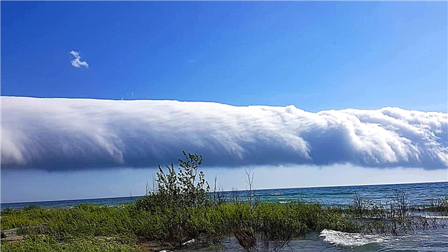
Storm Collar
Another name is gross cloud. It is also the common name for a certain variety of cumulonimbus clouds resembling a long shaft in shape. Often a thunderstorm collar forms on the border of atmospheric fronts at an altitude of 100 to 2000 m. It brings with it barrages, showers, thunderstorms, and pressure drops near the surface of the earth. Morning gloria is considered the rarest variety of thunderstorm collars.

Fallstreak effect
When a gap appears in a continuous layer of Altocumulus or Cirrocumulus clouds, this is the Fallstreak effect. Large holes appear as a result of falling ice crystals. They are formed in the upper tiers or even in the exhaust gases of a flying airplane.

Subject to several conditions (air temperature, humidity, supercooled drops of water), crystals during the fall absorb water and increase in size. The water in the cloud evaporates and a gap forms.
Lenticular clouds
Lenticular (lenticular) clouds do not move across the sky regardless of wind strength. They arise between two air layers or on the crest of air waves. Stability is due to the fact that the processes of condensation and evaporation occur continuously in wave flows. Often located near mountain ranges at an altitude of 2-15 km.

Clouds of Calvin Helmholtz
They resemble sea waves and form when two air layers move at different speeds. In this case, the upper layer moves faster, the lower - more slowly.More common in strong winds and changing air densities.

Mushroom cloud
A mushroom-shaped cloud is formed not only as a result of nuclear or thermonuclear explosions. It can form subsequently in an ordinary explosion, provided that there is no different interference (for example, wind). This also includes explosions caused by a meteorite fall, volcanic eruption.

Silvery clouds
This rare phenomenon has several names. Among them are night glowing clouds. The fact is that they can be considered only under the condition of deep twilight or during a solar eclipse. These clouds are located quite high - on average, at an altitude of 82 km. Their study was conducted not only from Earth, but also with the help of rocket probes.

Interesting fact: a great contribution to the study of silver clouds was made by the Russian astronomer - Vitold Cerasky. It is proved that this phenomenon is characteristic not only of the Earth, but also of other planets, for example, Mars. In 2007, the NASA AIM satellite was launched, among whose tasks is the study of silver clouds.
Clouds jellyfish
The clouds got this name due to the similarity in shape with jellyfish. They are formed in places where wet (from the Gulf Stream) and dry (atmospheric) air collide. The lower part, resembling tentacles, is formed due to dropping, but instantly evaporating drops.

Cloudy clouds
Clouds with a characteristic marsupial structure. Each cell has a size of about 500 meters. They are considered very rare (found a couple of times for 10 years) and are formed in connection with tropical cyclones.

Mother of pearl clouds
Formed at an altitude of approximately 20 to 30 km. Very rare, but they cannot be confused with other types of clouds due to their specific color. They are formed in the winter-spring period and are visible only before sunrise or after sunset.

Why are the clouds white?
The clouds are white due to the high content of cloud elements in them - drops and crystals. They reflect the sun's rays. The smaller the size of these elements, the whiter the cloud looks.

What is the difference between a cloud and a cloud?
In terminology, the concept of "cloud" is missing. This is the same cloud, but larger and darker in color. Unlike a white cloud, a cloud contains a large amount of moisture due to the high density of water droplets and brings precipitation.

Why are the clouds white and the clouds gray?
The clouds acquire gray and even black colors when viewed from the ground, because they are characterized by high density. They cast a shadow on each other, and also weakly transmit sunlight.
Interesting fact: if you fly right above the gray cloud, it will look white - the sun's rays fall from above.

What is a condensation trail from an airplane?
A condensation trail is a man-made or artificial cloud. It arises as a result of condensation of atmospheric moisture mixed with water vapor from the exhaust gases that are released by the engines of the aircraft. Over time, the trace disappears - its components evaporate.

How to determine the weather from the clouds?
The clouds do not provide complete information about the nearest weather conditions, but some of them can nevertheless foretell certain meteorological phenomena:
- Cumulus - as a rule, good weather without precipitation.
- Cumulonimbus (denser) - located low above the ground, can portend rain.
- Cirrus - gradually descending lower to the surface of the earth, may indicate precipitation in the next 12 hours.
- Layered - rarely bring precipitation due to the small thickness.

Dense dark clouds portend precipitation. In this case, black indicates the absence of strong winds, brownish means the possibility of strong winds, and gray may indicate prolonged rain.
Sedimentation processes
Precipitation is formed mainly in the troposphere, since there is most water vapor.Fog forms near the earth's surface as a result of the accumulation of condensation products.
Precipitation is formed only in those clouds, which are composed of large cloud particles (0.1-7 mm). They become heavy, cannot be held in the cloud and fall out in the form of precipitation. Precipitation is precipitated from the clouds or deposited on the surface from the air.

Precipitation:
- cover - monotonous, long;
- drizzling - non-intense, monotonous;
- rain showers are characterized by sharp fluctuations.
Precipitation on the surface:
- dew;
- frost;
- ice (formed on any surface due to the freezing of precipitation particles);
- sleet (formed only on the surface of the earth).
Unclassified precipitation:
- ice needles;
- Zolation (a rare occurrence in the form of large water bubbles that occur during a thunderstorm).

Cloud exposure methods
Modern science has discovered some ways to influence the clouds. In particular, the dispersion of supercooled clouds, fog, the effect on clouds carrying hail. In this case, the microstructure of the clouds, as well as their phase state, is changed artificially.
For example, in order to disperse a supercooled cloud, refrigerant reagents or iodine particles of ice-forming substances are introduced into it from an airplane. These substances contribute to the formation of a large number of crystals - the density of water droplets decreases and the cloud disperses. To influence the fog, ground installations of a similar nature are used.
Artificial precipitation is also possible, for example, during forest fires. To do this, using an aircraft, reagents are introduced into the cloud - silver iodide, or special pyrotechnic compositions.


